Data Pre-processing
RUBEM model applications require data input at a specific format and quantity. This manual provides the steps for using the preprocessing scripts to prepare model data for the RUBEM model. The scripts described here are available in the RUBEM repository on GitHub. We recommend that you use a specific Conda environment for this step.
Conda Environment
A conda environment is used to run the scripts available for preprocessing. A conda_env.yml file is available for creating the environment with necessary libraries and packages for running all scripts. For more details see the related documentation.
Use the terminal or an Anaconda Prompt for the following steps:
Create the environment from the environment.yml file:
conda env create -f conda_env.yml
Activate the new environment:
conda activate myenv
Verify that the new environment was installed correctly:
conda env list
Available Scripts
TIFF/GeoTIFF to PCRaster Map File Format
The function of the script allows to convert a file in format .tif to a .map file.
Note
The model requires input rasters to be in PCRaster map format, each file also has to match the appropriate PCRaster value format, see File Formats for more information.
For correct output file format code, change the line 55 (outputType) from preprocessing/tif2map.py must be modified according to table follows:
Soutce type |
Target value scale |
|---|---|
GDT_Byte |
VS_BOOLEAN |
GDT_Int32 |
VS_NOMINAL |
GDT_Float32 |
VS_SCALAR |
GDT_Float64 |
VS_SCALAR |
Call the function as shown:
tif2map('/path/to/files/to/be/converted')
TIFF/GeoTIFF to PCRaster Tss File Format
The function of the script allows to convert a serie of .tif to pcraster map-series at format *.001, *.002 …. These maps represent the meteorological forcing map-series, that are series of input maps with the time step indicated in each filename. The filenames have a strict format with 8 characters before a dot (.), and three characters after the dot.
Call the function as shown:
myModel= tif2pcrTss('/path/to/tiff/series','run','/path/to/clone.map')
First argument folder must have an structure as follows:
+---series
|   etp1.tif
|   etp2.tif
|   etp3.tif
...
Define second argument as “run” output files look like follow:
+---series
|   run00000.001
|   run00000.001
|   run00000.001
...
Third argument must be a file in format VS_BOOLEAN .map and nrOfTimeSteps must match the number of files to be converted (e.g. 8 files of etp, nrOfTimeSteps = 8).
PCRaster Tss File Format to TIFF/GeoTIFF
The function of the script allows to convert a serie of pcraster map-series at format *.001, *.002 … to *.tif file format.
Call the function as shown:
pcrTss2Tif('/path/to/files/to/be/converted', '/path/to/DEM.tif')
First argument folder must have an structure as follows:
+---series
|   run00000.001
|   run00000.001
|   run00000.001
...
Second argument corresponds to the Digital Elevation Model in *.tif format used to get mask coordinates, projection and driver information for the conversion.
Get Maximum and Minimum Value Map
This script allows you to get a map for variables as Minimum NDVI and Maximum NDVI from an historical series of files in *.tif format. To run the script, the following variables must be setted:
Input_path =  'Directory containing the files'
dem_source = 'Path to Digital Elevation Model (DEM) with same resolution and size that input_path files'
outpath_min = 'Path and name minimum output file, example=/path/ndvi_min.tif'
outpath_max = 'Path and name maximum output file, example=/paht/ndvi_max.tif'
Input_path folder must have an structure as follows:
+---series
|   etp1.tif
|   etp2.tif
|   etp3.tif
...
Kriging Method
The RUBEM model uses meteorological forcing variables as precipitation and evapotranspiration. In general, meteorological data is available for specific locations (stations). This script allows you to generate spatialized maps for the variable from discrete data using the kriging method.
Call the function as shown:
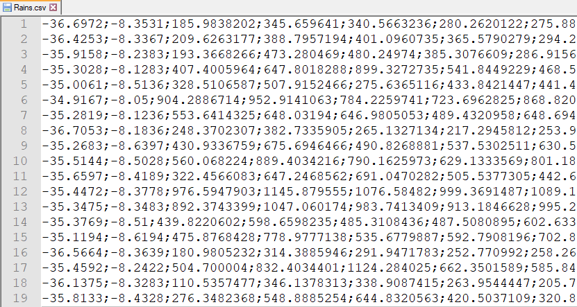
Krige_Interpolation('/path/for/output/files/','/path/and/filename/dem.map','/path/and/filename/CSV/file/data.csv')
The first argument corresponds to the folder to store the maps generated. The second argument corresponds to the Digital Elevation Model in *.tif format used to get mask coordinates, projection and resolution for the files created.
The third argument must be a file in format *.csv, each row corresponds to one station data. First and second columns correspond to station Longitude and Latitude, others columns contain data for each timestep. Figure below shows an example of the format of the file.
To use this script, the following conditions must be met:
A minimum of 3 stations data is mandatory;
No value data is not allowed;
Projection of station coordinates must correspond to DEM projection;
nrOfTimeStepsmust be minor or equal to the number of columns data.